
We can view Earth through the photographic images from satellites. The swirls, colors, shapes. The images are taken by the Landsat-7 satellite and the Terra Satellite's Advanced Spaceborne Thermal Emission and Reflection Radiometer (ASTER).
"Meandering wadis combine to form dense, branching networks across the stark, arid landscape of southeastern Jordan. The Arabic word 'wadi' means a gully or streambed that typically remains dry except after drenching, seasonal rains."
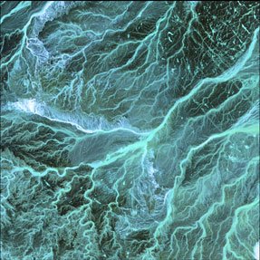
Jordan: Image taken 5/17/2001 by ASTER
"The Dasht-e Kevir, or valley of desert, is the largest desert in Iran. It is a primarily uninhabited wasteland, composed of mud and salt marshes covered with crusts of salt that protect the meager moisture from completely evaporating."
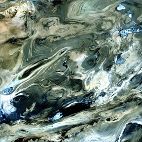
Dasht-e Kevir: Image taken 10/24/2000
"Vivid colors belie the arid landscape of northern Chile where the Atacama Desert, one of the world's driest, meets the foothills of the Andes. Here salt pans and gorges choked with mineral-streaked sediments give way to white-capped volcanoes."
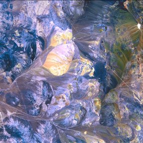
The Andes: Image taken 10/28/2001 by ASTER


6 comments:
AMAZING!!!
Man alive, Ruth! It's like photos of marble! No, I hadn't heard of this before. Cool discovery!!
Thanks, that is a wonderful site!
oh i love this!
it just makes me feel so separated from the planet i live on...knowing that the only way i will ever see this with my own eyes is floating in the atmosphere somewhere.
who knows...it could happen....
This reminds me of the interactive graphic that zoomed in from outer space to the molecular level of a leaf, remember that one? See, it's all the same (vibrations, that is) except at different scales.
Yes, Ing. It's all one!
Post a Comment